
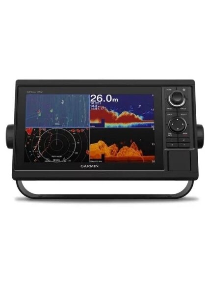
Garmin GPSMAP 1022xsv
Kodas: 010-01740-02Garmin GPSMAP 1022xsv, 010-01740-02 - prekės aprašymas
10-inch Chartplotter/Sonar Combo Is All-in-1 Solution
10-inch color display with keypad interface and multifunction control knob
High-sensitivity internal 10 Hz GPS and GLONASS receiver
Built-in single channel CHIRP sonar, CHIRP ClearVü and CHIRP SideVü scanning sonar and Panoptix™ support (transducers sold separately)
Fully network capable for Garmin Marine Network and NMEA 2000® plus NMEA 0183 support
Supports optional BlueChart® g3 Vision® premium charts
Experience an advanced all-in-1 solution with our 10-inch GPSMAP 1022xsv keyed combo. It has built-in support for Garmin CHIRP sonar, CHIRP ClearVü and CHIRP SideVü. It also has built-in support for Panoptix all-seeing sonar and premium Garmin sonar modules (transducers sold separately). Features a large, bright screen coupled with a quick and easy-to-use keypad interface with user-programmable keys and a multifunction control knob.
Complete Network Sharing
Garmin Marine Network support allows sharing of sonar, maps, user data, dome or open-array radar, IP cameras and Panoptix™ sonar among multiple units. Includes NMEA 2000 network connectivity and NMEA 0183 support for autopilots, digital switching, weather, FUSION-Link, VHF, AIS and other sensors.Built-in ANT® Connectivity
Enjoy built-in ANT wireless connectivity directly to quatix® marine watch, Garmin Nautix™ in-view display, gWind™ Wireless 2 transducer, GNX™ Wind marine instrument and wireless remote controls.The Ultimate Connected Boating App
Built in Wi-Fi gives you access to the free all-in-one ActiveCaptain™ app, so you can manage your marine experience from nearly anywhere. It creates a simple yet powerful connection between your compatible mobile device and your Garmin chartplotter, charts, maps and the boating community. Wherever you are, you’ll have unlimited access to your cartography, the ability to purchase new maps and charts and access to the Garmin Quickdraw™ Contours Community. Stay connected with smart notifications on your chartplotter screen. You can also plan a trip or prefish a lake, and ActiveCaptain will automatically sync with your chartplotter. Even get notifications for software updates, and decide when to download them on your device.Built-in Sonar Capabilities
Right out of the box, you have access to some amazing sonar capabilities; all you have to add are transducers. Comes with built-in Garmin 1 kW CHIRP sonar, CHIRP ClearVü and CHIRP SideVü scanning sonar. It even supports Panoptix all-seeing sonar, premium Garmin sonar modules and a wide range of transducers (sold separately).Networked combos can share their internal sonar with any other device on the network. You can also choose what information is overlaid on the sonar screen; for example, radar, time of day or GPS speed.
Heading, Position Refreshed 10 Times per Second
Fast, responsive built-in 10 Hz GPS and GLONASS receiver refreshes your position and heading 10 times each second to make your movement on the screen more fluid. It makes dropping up to 5,000 accurate waypoints — and finding your way back to them — quick and easy.Upgrade to the Best Maps on the Water
Upgrade to optional premium BlueChart g3 Vision charts and LakeVü g3 Ultra maps. These add features such as high-resolution relief shading of bottom structure — which provides more 3-D relief than contours alone — satellite imagery and more.Our Premium Sonar Support
Quickdraw Contours to Create Your Own HD Maps
Instantly create personalized HD fishing maps on screen with 1-foot contours. Tailor them to fit your needs. These are your maps — you own them. Keep the data to yourself, or share it with the Quickdraw Community on Garmin Connect™.Built-in SailAssist Features
To help you gain a wind-maximizing competitive edge, your chartplotter features a pre-race guidance page that shows your virtual starting line along with data fields showing laylines, time to burn before the start and a race timer that can be synchronized across all your networked Garmin GPS products. In addition, other supported sailing features include an enhanced wind rose, heading and course-over-ground lines, set and drift, true and apparent wind data and more.GPX Waypoints Transfer
If you have waypoints, tracks or frequently used routes stored on another manufacturer’s GPS product — or on a Garmin handheld device — it’s easy to transfer those items to your new Garmin chartplotter via industry-standard GPX software formatting.¹Auto Guidance is for planning purposes only and does not replace safe navigation operations.
iPhone and iPad are trademarks of Apple Inc., registered in the U.S. and other countries. App Store is a service mark of Apple Inc. Wi-Fi is a registered trademark of the Wi-Fi Alliance.
Prekės ženklasGARMIN-
Garmin GPSMAP 1022xsv, 010-01740-02 - prekės specifikacijos
Bendra
FIZINIAI MATMENYS 12.5" x 7.3" x 2.7" (318 x 185 x 69 mm)
SVORIS
4.1 lbs (1.85 kg)ATSPARUMO VANDENIUI KLASĖ IPX7
EKRANO TIPAS WSVGA, NP
RODYMO DYDIS
8.8" x 4.9"; 10.1" diagonal(22.4 x 12.5 cm; 25.7 cm diagonal)
EKRANO SKIRIAMOJI GEBA 1024 x 600 pixels
MONTAVIMO GALIMYBĖS Bail or flush
RAKTINIAI PAGALBOS MYGTUKAI Su mygtukais
Žemėlapiai ir atmintis
GALIMA NAUDOTI DUOMENŲ KORTELES 2 SD™ cards
KELIO TAŠKAI 5,000
STEBĖJIMO TAŠKAI 50,000
TRASOS 50 saved tracks
MARŠRUTAI 100
Jutikliai
GPS
GLONASS
INTEGRUOTAS IMTUVAS
IMTUVAS
10 HzSUDERINAMA SU NMEA 2000®
SUDERINAMAS SU NMEA 0183
PALAIKO WAAS
Integruoti žemėlapiai
POTVYNIŲ IR ATOSLŪGIŲ LENTELĖS
Pasirenkamas žemėlapio palaikymas
BLUECHART G3
BLUECHART G3 VISION
LAKEVÜ G3
LAKEVÜ G3 ULTRA
GARMIN NAVIONICS+™
GARMIN NAVIONICS VISION+™
TOPO 100K
STANDARTINIAI ŽEMĖLAPIAI
GARMIN QUICKDRAW CONTOURS
RASTRINIŲ JŪRLAPIŲ PALAIKYMAS
Kartploterio funkcijos
SUDERINAMA SU „GARMIN SMARTMODE“ (PRITAIKOMOS STEBĖJIMO NUOSTATOS)
PALAIKO AIS (STEBI NURODYTŲ LAIVŲ PADĖTĮ)
PALAIKO DSC (RODO PADĖTIES DUOMENIS IŠ DSC PALAIKANČIO VHF RADIJO)
PALAIKO SU „FUSION-LINK ™“ SUDERINAMUS RADIJO IMTUVUS
„GSD™ BLACK BOX“ SONARO PALAIKYMAS
„GCV™ BLACK BOX“ SONARO PALAIKYMAS
SUDERINAMAS SU „ACTIVECAPTAIN“
yesSUDERINAMA SU GRID™ („GARMIN“ NUOTOLINĖS ĮVESTIES ĮRENGINIU)
SUDERINAMAS SU BELAIDŽIU NUOTOLINIU VALDYMU
BURIAVIMO FUNKCIJOS
Elektriniai įrenginiai
MAITINIMO ĮVESTIS 10 to 32 Vdc
TIPINĖ TIEKIAMOJI SROVĖ ESANT 12 V NS 1.9A
MAKS. TIEKIAMOJI SROVĖ ESANT 12 V NS 2.7A
MAKS. ENERGIJOS SUVARTOJIMAS ESANT 10 V NS 32.4 W
Sonaro funkcijos ir specifikacijos
RODOMAS SONARAS
ATIDUODAMOJI GALIA 1 kW
ĮPRASTINIS SONARAS (DVIGUBO DAŽNIO / PLUOŠTO) Integruotas (vieno kanalo CHIRP, 70/83/200 kHz, L, M, H CHIRP)
„CLEARVÜ“ Taip, su CHIRP (integruota)
„SIDEVÜ“ Taip, su CHIRP (integruota)
PANOPTIX™ SONAR
„LIVESCOPE“
Kontaktai
NMEA 2000® PRIEVADAI 1
NNMEA 0183 ĮVESTIES PRIEVADAI
1NMEA 0183 ĮVESTIES (TX) PRIEVADAI 1
VAIZDO ĮVESTIES PRIEVADAI
1 BNC„GARMIN MARINE NETWORK ™“ PRIEVADAI
2SKAMBINIMAS NAUDOJANTIS „BLUETOOTH®“
ANT+™ (RYŠYS)
„GARMIN WI-FI®“ TINKLAS (VIETINIS RYŠYS)
Realios prekės išvaizda gali šiek tiek skirtis nuo esančios nuotraukoje. Prekės, kurias gausite, gali būti kitokioje pakuotėje bei kitokios išvaizdos ar formos. Informacija produkto aprašyme, kuri pateikiama elektroninėje parduotuvėje, yra bendro pobūdžio, todėl nėra tapati informacijai, nurodomai ant produkto pakuotės. Ant produkto pakuotės nurodoma informacija yra išsamesnė ir gali šiek tiek skirtis nuo informacijos, nurodomos elektroninėje parduotuvėje pateiktų prekių aprašymuose. Visada rekomenduojame perskaityti ir vadovautis informacija, esančia ant prekės pakuotės. Akcinių prekių kiekis yra ribotas.
Paslaugos teikimo sąlygos:
- Prekės pristatomos nurodytu adresu per 1-5 d. d. nuo užsakymo patvirtinimo;
- Šventinių dienų ir iškirtinių akcijų laikotarpiu (pvz.: Šv. Kalėdos, Black Friday) prekių pristatymas dėl didelio kurjerių užimtumo gali pailgėti 2-5 d. d.;
- Prekių pristatymas vykdomas darbo dienomis (I-V), 08:00 – 18:00 val.;
- Dieną prieš prekės pristatymą informuojama sms žinute apie prekės išsiuntimą, statuso pasikeitimą;
- Pristatymo dieną apie siuntos pristatymo laiką 1 val. tikslumu informuojama SMS žinute;
- Pristatymo kaina priklauso nuo prekės svorio:
-
PREKIŲ KATALOGAS
- NAUJOS PREKĖS
- Spininginiai masalai
- Meškerės Spiningai
- Seliavų žūklė Džigai, čeburaškos Populiariausios dugninės žūklės prekės
- Karpinė fyderinė žūklė
- Stovai laikikliai
- Valtys
- Valčių varikliai
- Suktukai / Karabinai / Stabdžiai / Svareliai
- Žvejybos reikmenys
- Avižadrebio žūklė
- Signalizatoriai Bemasalinės Muselės Seliavoms
- Ritės
- Valai, pavadėliai
- Kabliukai
- Plūdės
- Šamų žūklė
- Krepšiai kuprinės
- Dėklai meškerykočiams Graibštai sieteliai vorai Kėdės Gultai Svarstyklės Palapinės Skėčiai
- Akumuliatoriai
- Echolotai
- Velkiavimo įranga Laikikliai staliukai laivams
- Alkotesteriai
- Jūriniai masalai pilkeriai
- Apranga
- Kajakai / baidarės / Irklentės
- Laivyba
- Railblaza
- Žiema
Prekių katalogas
-
PREKIŲ KATALOGAS
- NAUJOS PREKĖS
-
Spininginiai masalai
- Silikoniniai masalai
-
Vobleriai
- Westin Swim Glidebait
- Iron Wolf "BANDY"
- Iron Wolf „BANDY DR“
- Iron Wolf T REX
- Iron Wolf PULSE
- Iron Wolf „PULSE DR“
- Iron Wolf AGENT
- Iron Wolf DOMUS
- Iron Wolf FOBUS
- Iron Wolf MASTER TWICH
- Iron Wolf SHOCK
- Iron Wolf THUNDER
- Iron Wolf VIBRO MAX
- Iron Wolf VIRTUOSO
- Jaxon HS SPIRIT
- Horn QM
- Jaxon Virtus
- Kenart voblerių rinkiniai
- BAKER JERKBAIT magnetic system
- Baker Suspending Shad
- Jaxon Ferox DR
- Jaxon Stynka F
- Jaxon Stynka UV F
- Jaxon Diver F
- Jaxon Diver UV F
- JAXON Fat Pike 2-SEC UV F
- JAXON Karaś F
- JAXON Karaś SW (Shallow water)
- JAXON Karaś UV F
- JAXON Carpan F
- JAXON Nidor F
- JAXON Classic F
- JAXON Płetwal F
- JAXON Ferox F
- JAXON Ferox TURBO F
- JAXON Ferox UV F
- JAXON Gelon F
- JAXON Pike F
- JAXON Fat Pike F
- JAXON Pike UV F
- JAXON Fat Pike 2-SEC F
- JAXON Pike Max F
- JAXON Fish Max F
- JAXON Troll F
- Magic Fish Frog 3
- Magic Fish Frog Mini
- Micron 2cm
- Żuk Smużak 2cm
- ATRACT Frog 4,5cm; 5,5cm
- Beetle
- Chrabąszcz Smużak 3,0cm
- Tail spinner
-
Blizgės
- IRON WOLF blizgės
- Alga
- Flex Gnom Blask
- Flex Gnom Classic
- Flex Gnom Duo
- Flex Gnom Rab
- Flex Gnom Scot
- Flex Gnom Spark
- GT-BIO Armour
- GT-BIO Fractured Fish
- GT-BIO Leapfrog
- High-Speed Whirl
- Karaś Blask
- Karaś Classic
- Karaś Duo
- Karaś Fir
- Karaś Krol
- Karaś Natural
- Karaś Perk
- KARAS RAB
- Karaś Scot
- Karaś Spark
- Karaś Tor
- Prism
- Psycho
- SEA Trout
- Shock Wave
- Troć Classic
- Ukla Classic
- UKLA RAB
- Ukla Scot
- Ukla Spark
- Ukla Tor
- Body spinner
- VIB masalai
- Cikados
- Long cast-jigging blizgės
- Džigai, čeburaškos...
- Šamams
- Varlės
- Sukriukės
- Meškerės Spiningai
- Seliavų žūklė
- Džigai, čeburaškos
- Populiariausios dugninės žūklės prekės
- Karpinė fyderinė žūklė
- Stovai laikikliai
- Valtys
- Valčių varikliai
- Suktukai / Karabinai / Stabdžiai / Svareliai
- Žvejybos reikmenys
- Avižadrebio žūklė
- Signalizatoriai
- Bemasalinės Muselės Seliavoms
- Ritės
- Valai, pavadėliai
- Kabliukai
- Plūdės
- Šamų žūklė
- Krepšiai kuprinės
- Dėklai meškerykočiams
- Graibštai sieteliai vorai
- Kėdės Gultai
- Svarstyklės
- Palapinės Skėčiai
- Akumuliatoriai
- Echolotai
- Velkiavimo įranga
- Laikikliai staliukai laivams
- Alkotesteriai
- Jūriniai masalai pilkeriai
- Apranga
- Kajakai / baidarės / Irklentės
- Laivyba
- Railblaza
- Žiema
Elektroninė parduotuvė
© 2026 MB "Žvejyba FWS". Be MB "Žvejyba FWS" sutikimo draudžiama kopijuoti ir platinti svetainėje esančią informaciją.
Garmin GPSMAP 1022xsv
Į krepšelį -